Looking good. NNW 3000m. Most over the Pass and to Avila.

1pm

1500

wind at 1500 and track 1500hrs

X section to Avila over time


According to the trace the inversion has risen to 3200m,  and with over 26 §C we should start to get good quality thermals (about time!).    It seem during most of the day we have  a NW component, though moving more North at end of day.  A far more typical  forecast for July.  Should be good, but Avila will probably be the limit due to the north wind there, though coming back a bit or even all the way would be feasable


Mike´s Vids.

[youtube]//youtu.be/wH1LCB0Oq5A[/youtube]

[youtube]//youtu.be/TV7BuyQPHUk[/youtube]


What happened

At last some really nice conditions, and the result, lots more success for all.

Triple time , height and distance PB for Gary

Here is Mikes arrival at Avila

[youtube]//youtu.be/GPYUhpsqsco[/youtube]


Lighter Winds and Warmer

1pm

1500


Not dissimilar to the last few days but with  lighter winds and a bit warmer.  Also the inversion is less pronounced, so we may be finally up for a decent xc day towards Plasencia!

Laste start once again due to slow conditions.

Here is Catherines track log of yesterday.

Catherine[s track

Mikes video

[youtube]//youtu.be/2b_Tu4T6OIQ[/youtube]

Mike Thomas´s videos

Mike`s track. Tuesday

Mike Thomas did a great video blog last year during his trip.  This year, he is slightly less ambitious, but still posting his daily flights as soon as he finishes editing each day on his iPad

Here is the set so far:

Tuesday

Monday

Still North, but perhaps lighter.

1pm

1500

wind at top of lift and track for section

Section of track


Situation.

Still under the influence of the extensive Atlantic high and a northerly airflow.  Today perhaps not so inverted and a little less windy.  Once again winds at low levels light, but we can expect them to  increase by the evening as mix down occurs.

Once again we should fly to the West, and perhaps be a little more adventurous than Barco.

Best flight from Denis yesterday is below.  A great low save after Santiago de Collado

Denis.


NE, still pretty inverted.

1pm

12

1500


We continue with high pressure and a northerly flow.  Things will really depend upon the ground temperature getting up.  We have a strong inversion early on around 200m above take off which will ease as the afternoon goes on.  Once again, like yesterday quite scrappy turbulent climbs only really getting sorted quite late in the afternoon.

We could go for a late trip up the hill, but the wind strengths on the forecasts are quite high.   So we should go up reasonably on time, but a little later after 11am.  The eastern component makes for quite a turbulent time near the hill.  Today we will all be following Ian in the Barco direction.

It is worth noting that eastern winds can often be blocked by the mountain relief, especially on inverted days.  It can get windy quite suddenly as the thermals start working and the inversion breaks down.  Have a look at this short video I made to see why.  https://vimeo.com/64294975.


For Bob.  go to the FARMACIA, (chemist).  ask for pastillas o chicle anti mareo.  (mareo de viaje o mar).  I could not find the ones I thought I had.


The Collector

As requested by Emily some months back.  This is the full Dauntless Dan adventure after he came spiralling down on his reserve.

French subtitles and full HD


North Wind, OandR for Ian and over the Pass for 5

mid day

Kew T 1500

Sectionacross mountains and winds at 1800m

Cross section


Stability in the Peninsula, especially compared with the rest of Europe.  We have this northern flow,which is quite strong  at altitude.  However, initially the strong wind will remain above the inversion, though as mixing starts this wind will come  down and perhaps make the evening flight once again difficult.

A problematic day for long xcd as most thermals won’t go above 2600m  , so going over the back will be a risk.

there is quite a difference in  forecast from NOA and the spanish institute.  If we believe the americans we should fly towards Avila, and the other forecast towards Barco.  The most likely is the Barco direction.

What Happened.

Late start, but eventually with NW wind so the majority of us went for the Pass, though Ian headed for Barco.   Over the Pass were Bob, who threw up a few times and had to land, and Mike L, Rob myself and Mike T, who made the best with 48km.  Meanwhile , Ian flew back from the Barco valley to the Pass, then back to Barco with over 8 hours logged on his tracker and probably 80km + flown.

Mike T, Blue. Ian Green.

The Week ahead, Update Monday

Monday 1pm

1500 Monday

Cross section of Gredos

Airspace south

Situation

An active cold front is going through the Peninsula today leaving very unstable air behind leading to rain and storms.  The situation looks good tomorrow with capped instability.  However, although flyable winds are forecast, up top they are strong and it could get breezy.

weeks overall weather

I will explain why in the briefing, but N components winds make life difficult if you want to fly over 60km unless we go off down wind over the back of the Gredos Mountains.  Flights this way  can make life very complicated as I will explain, but our best option for 100km flights over the next few days until Friday.  In the past we almost never make these flights, but this week with 2 vans it is an option.   However, we will be baling over the back into a 1500m lee side, so there  are a few issues that must be clear, more subsidence and thermal suppression that lee side rotor, though we cannot discount that either.

Could be an epic week, and maybe a lot of Van time.

Monday morning.

Still looking similar as predicted.  Plenty of  lingering Stratocumulus which we hope will thin by 11am.  Quick brief about trackers at 10.45am and leaving for take off soon after IF the mountain is clear.  If not we will linger in the Valley until it starts to clear.

Check Follow the action page to see your tracker number which you will maintain all week.


Sunday. Not really flyable today. Frontal and strongish winds.

Monday looking good.  We may attempt a crossing of the Gredos to the South.

Spanish Nationals. Last day. Felix Rodriguez new Spanish Champion

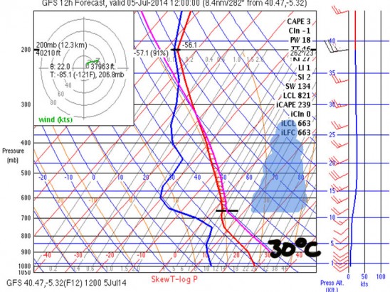
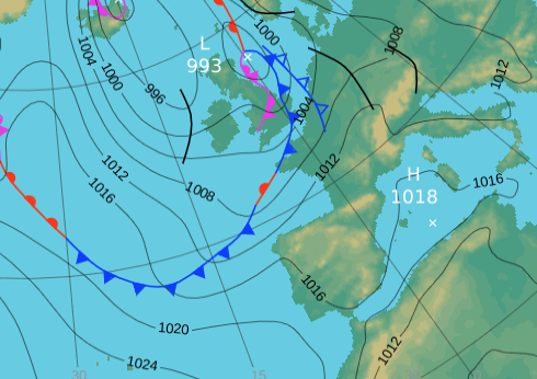
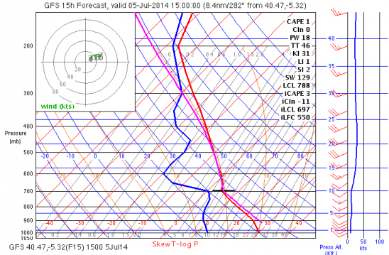
Today we have a prefrontal forecast with moderate SW winds, around 20km/hr at take off levels and rising to near 30km/hr at 3000m.  It should mainly a blue day according to the Skew T, though with temperatures much higher than yesterday we will see some cumulus which will be quite deep in areas of convergence.   With ground temperatures above 28 degrees there should be Cu development.

Without a doubt this is a 200km+ day.  We will have convergence in the flatlands, thermal tops a little above 300om and a good tailwind to make for a very long flight.  All the ingredients to make a huge open distance flight.  Typical of the area during these dates.

HOWEVER, this is the last day of the competition and the prize giving is supposed to be around 8 -9pm, so we cannot of course set a very long task.

The wind strength will not allow any sort of fancy turn point scenario.  -we must go down wind as in other days.   The obvious task for a day like today would be a repeat of task 2, or Goal in Arcones.  However, we must reduce the distance for the above mentioned reasons.   Probably similar to yesterday at a maximum of 100km.

Conditions at launch maybecome hectic with the stronger wind than yesterday, so once again we need to get into the early, but no pre turn points due to the wind.   The same style start as yesterday is advised.
1pm
30º

What Happened.

We never got off as although it was an epic looking day the wind never came on well enough at PN for a safe launch for the event.

Prize giving in the square that evening with the usual ceremonial ducking in the square’s fountain for the winners.  I was also thrown in an completely submerged, perhaps for the terrible weather forecasts over 3 of the days.  Anyway, weather is certainly looking up for this week.