Light NE, reducing instability. A trip down to Barco

Situation

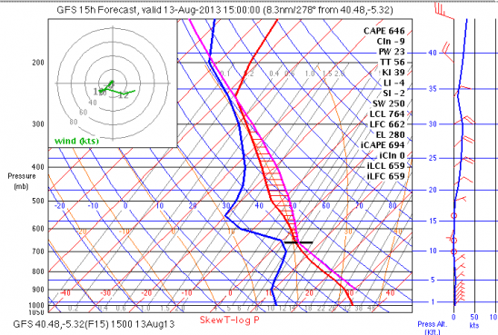
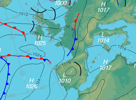
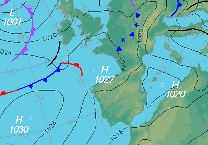
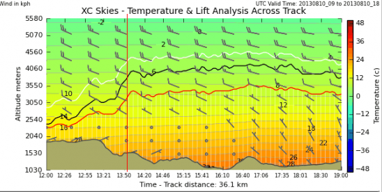
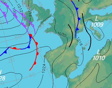
Cool air at altitude and the heat low gives us like yesterday another day of potential Cbs or at least large powerful congestus clouds.  This instability should be markedly reduced tomorrow and may even occur during today….but don´t bet on it!

At 8.30 the wind at take of is SE.  This should start pulling onto the hill by around 11am if all goes well.  We will go up the hill when the windsock shows signs of change to arrive when it is on the hill for those who want to go early.

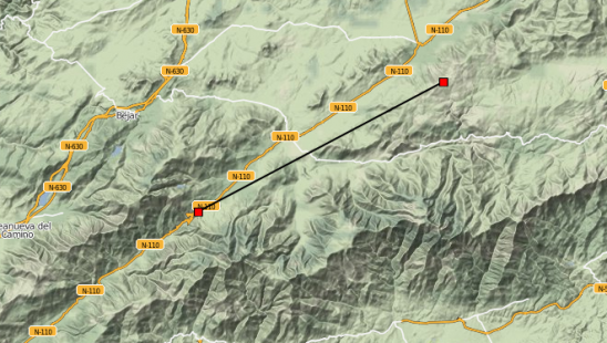
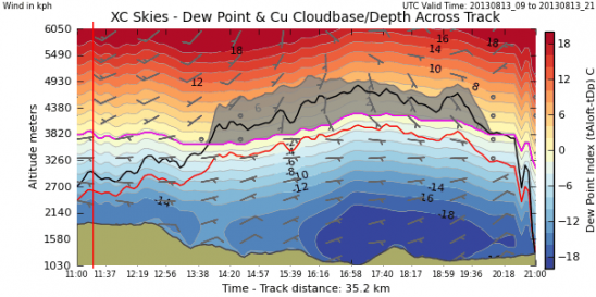
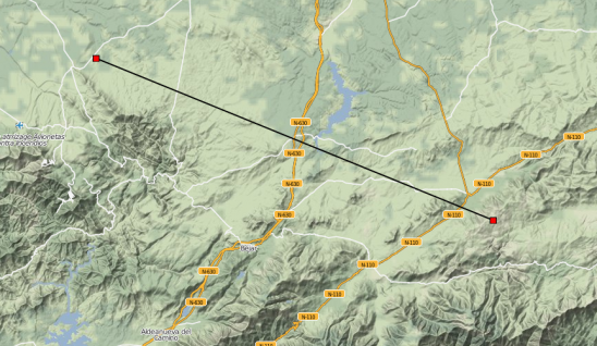
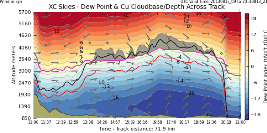
Cloud base over 3000m and rising to near 4000m in the late afternoon, but like yesterday, that can only be utilised if it does not go to Cbs.  The XC section below is a  flight to the Pass beyond Barco as that would be the downwind direction today.  If conditions are good and we can fly to the NW and not to Barco, that would be best, avoiding much of the build up on the mountains.

What Happened

Nice conditions with Cu which only overdeveloped in the Avila Valley.  Many of us flew to Barco and tried to go back a bit but were then drawn back to the Cafe at Barco.  I flew tandem with Jenny, and Mark B, Chinie , Bill, Mark , Phil and Huw in the Barco Bus.
1pm

1500

Xc section to Tornavacas

X section to Tornavacas

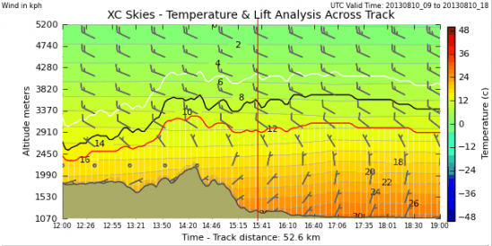
X section to NW

X section to NW


Piedrahita-Belanlga de Duero 234km on Sunday by Godo Fedo

Well, Sunday was pretty epic after all.  Looked amazing from the van as I drove back from Madrid, and Chinnie did it some justice on his late afternoon flight to the Pass and back.  Bill will be annoyed to see that his bomb out at Villafranca put an end to something potentially very big!

Nigel Page´s article on Piedrahita Flying Tips for Derbyshire Club

This is an excellent article written by Nigel Page for the Derbyshire Club visit.  Nigel Has been visiting us for over a decade and has had heaps of airtime and distance here.  He is also the Author of 50km or Bust.

Piedrahita PG Tips – Nigel Page

page1image1056

This is a quickly written draft of a few points about flying in Piedrahita I think are probably the most useful for Brits coming out to fly with Steve Ham for the first time. If any of it sounds a bit like stuff Steve tells you or if any of the pictures look like the one’s he shows you that’s probably a good thing. If any seems at odds then listen to Steve!

Piedrahita is a fascinating place to fly but there are aspects quite different to the UK or the alps. There is always an element of chance when trying to stay up. The idea is to give ourselves the best odds, roll the dice, and try not to get too upset if we end up on the ground early.

Getting Started

The first thing to remember is that the wind we feel at the Peña Negra take off around mid-day is usually not the geostrophic (meteo) wind. We may feel the geostrophic wind more once we are flying but it may only become apparent after we get some height. At take off we more usually feel the “thermal” wind drawn in by thermals rising from the plateau area and big Gredos mountains further back. Take off is also in a bit of a venturi area on the edge of the hill so the wind is generally lighter once we get some distance from the edge.

The high areas will have been heated strongly during the morning and already producing thermals, but the slope down towards the town will have been heated less because it is tilted away from the morning sun. As the sun gets higher the slopes below take off receive increasing amounts of heat and eventually start to produce thermals. However, thermal activity in the high areas also continues increasing, pulling more air over the edge of the hill increasing the wind at the take off area until (usually) it gets blown out. The result is that there is a limited “window” of opportunity to launch around mid-day while the slope is producing strong enough thermals to stay up, but it is not too windy to take off. Sometimes the thermals over the high ground will make cloud which, because of the angle of the sun, will shade the main slope we are going to fly, inhibit its heating, and make things difficult for us. Nothing is guaranteed!

Steve will try and get you airborne at the time which will give you the best chance to get going and stay up, so be ready to take off soon after he launches. Remember the

page1image22784

1

1

wind you feel at take off is not what is going to keep you up. Think thermal! Spines and Cloughs

The Peña Negra take off is at the back of a large bowl which has a number of spines (ridges) running down it with cloughs (gulleys or small valleys) between them. These features can be seen quite well on google earth. Thermals tend to originate on the spines rather than in the cloughs so it’s a good idea to try and stay over the spines. This picture is a sort of section across the spines looking down the slope of the hill.

The down side is that when we get sink on the hill, air falls into the cloughs and runs along them down the hill.

If we are low over a spine or in a clough and encounter sink we are likely to drop down the clough in the sinking air. Not nice!

The best way to avoid this is to keep well above the spines. If we now hit sink we have a good chance of escaping it. I like to keep high enough to be able to do at least one decent 360 without having to worry about the ground. This is also a good height to intercept thermals coming from the spines and enables me to manoeuvre with ease. If we don’t find lift we can fly along the spine towards the valley, perhaps zig zagging a bit to search for thermals triggering from the sides of the spine or adjacent areas, but

2

always keeping good clearance above the terrain. If we want to cross to another spine we should try do so quickly, staying high over the cloughs and making sure we arrive over the spine with plenty of height. If we are unlucky and don’t find a thermal over the spines it is a good idea to try and come out over the flat valley bottom before we get really low. This gives us a chance of finding a save from the flats before we have to land.

Left or Right?

The area immediately in front of the Peña Negra take off does not normally produce good thermals, so when we launch we have to decide whether we are going to go left to get over the “chalet” spine (Steve will show you where this is) or right to the faces on the other side of the power lines which run up the hill near the take off. If we are lucky there will be an obvious thermal with pilots climbing nearby and we can just go for it. With no other clues, the “chalet” spine usually works best but not always. In particular if there is a significant westerly wind we may have difficulty reaching the chalet spine and going right may work better anyway.

It can be a difficult call. Try and be positive about your decision, but keep looking around while you are crossing to the area you intend to search. If you find yourself against a significant headwind or pilots are sinking in front of you it might be worth turning back to try the other way.

The Big Spine

To the right of the big bowl in front of take off is the big spine. This is almost a hill in itself and but it is quite a distance from launch across the potentially sinky bowl. Once we have got some height near take off, particularly if there is a bit of a westerly wind, we might try and get over the big spine. If we have failed to climb near take off we might try and get onto the big spine lower down anyway and sometimes we can just skirt along the edge of the hill to it. A lot of stuff tends to go up over the big spine but finding it is not always easy.

This drawing tries to show some of the types of thermal we may find around the big spine area and other parts of the ridge.

page3image21064 page3image21224

3

Thermals From The Valley

Thermals from the flat valley are potentially some of the strongest because they can result from a release of hot air which has accumulated over a large area of the valley floor. On flat areas the trigger is often not obvious but the foot of the hill itself may be a trigger for air from the valley. We can sometimes move along the ridge staying quite high by picking up thermals released at the foot of the hill.

Thermals From The Slope

Air heated on a slope cannot accumulate as it can on the flat valley floor. It will slide up and may form a slope thermal running up the hill. If we 360 in a slope thermal we may have to deliberately move back towards the hill a little with each turn in order to keep climbing, the opposite of what we might do in a wind blown thermal where we move upwind a little on each turn. However a slope thermal may also break from the hillside and rise as a column or may “trickle” from the edge at the top. These thermals are usually weaker than those originating from air “cooked” in the valley because the hot air cannot accumulate on the hillside before releasing.

Sometimes if a number of gliders are on different parts of the hill we can see several different types of thermal at once. If we are struggling to climb in a poor slope thermal we should keep our eyes open for pilots or birds climbing strongly nearer the valley indicating a thermal released from the foot of the hill.

Thermals From The “Plateau”

These are potentially very strong for reasons similar to the thermals from the valley. We may find ourselves in a thermal which starts near the edge and creeps downwind over the “plateau”. There is a “but” though. We have to be careful that we can always get an easy glide back to the valley and remember that it can be very windy at the

page4image17608 page4image17768 page4image17928

4

edge. It’s usually not a good idea to take a weak thermal back over the “plateau”. If we cannot get back and clear the edge we will be in for a long hot walk!

Brits And Weak Thermals

Us Brits pride ourselves in how we can hang on in weak thermals and make distance by drifting downwind with them. However, in Piedrahita we more usually want to climb fast and glide. There are times to hang on in a weak thermal, but usually the time spent making those few extra hundred feet on top of a couple of a thousand metres or so is not worth it. If we are climbing very slowly we need to keep a close eye on where we are drifting and make sure it is somewhere we are happy to go!

Brits And Strong Thermals

Some clouds in Piedrahita can be very big and lift can get very strong towards cloudbase. Keeping clear of cloud with the 45 degree rule is a good idea.

Entering the cloud in Piedrahita is not like clipping the edge of the odd cloud in the UK. It can be very scary. If big clouds are about and staying up suddenly seems too easy it’s probably time to run away and land.

Going Cross Country

The group will seldom manage to stick together and usually distributes itself around the area. If we find ourselves much lower than the leading group or trailing some distance behind we should not try and “race” to catch up which will probably put us on the ground very quickly. We should concentrate on our thermalling and getting height. While we are airborne we are gaining experience and having fun, and once we have gained some height we can follow at a distance if we wish. If we are not happy following at a distance there are far worse ways of spending the afternoon than practicing our thermalling locally and admiring the scenery. The flat areas of the Corneja valley are safe landing even if it gets a bit windy.

© Copyright Nigel Page – August 2013

page5image18352 page5image18512  page5image18840

5

5

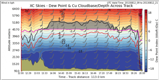
SW, Cloud base 4500m. Early CB

1pm

1500

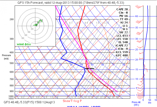
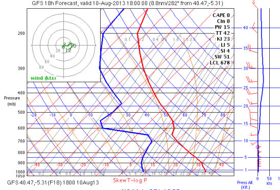
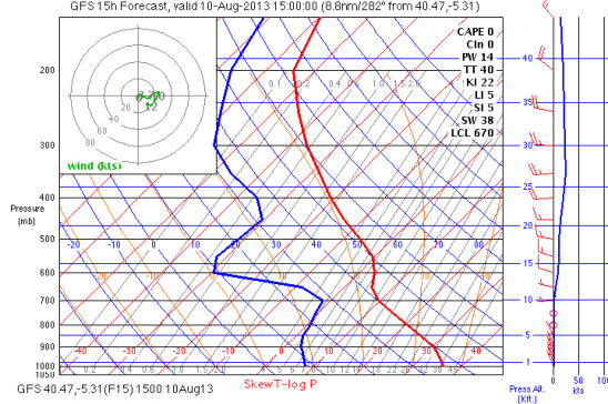
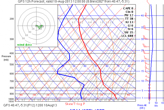
Skew T diagrams

For an explanation of how to read this please do some homework and read Skew T Basics on https://www.meted.ucar.edu.  You need to Join which is free, then look in the turorials under convective weather or Mountain Meterology

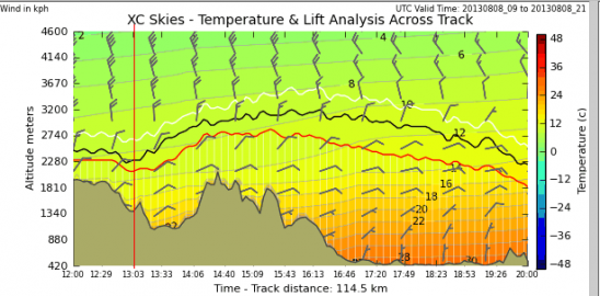
X section to Segovia

Briefing at 10.30am(need to discuss trackers use, airspace to the E, SW convergence and some general safety pointers).

On a separate Blog I will reproduce Nigel Pages article for the Derbyshire club which covers much of what I say but is well thought out  and deals with a  lot of the stuff on flying here.

Weather Situation

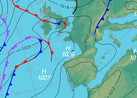
The ridge of high pressure between the two Highs has now turned to a Heat Low.   For today and tomorrow a trough in altitude may unstabilise things giving us more depth of cloud and some risk of large congestus and the odd isolated shower, especially towards Segovia.  Winds are from the SW about 15km, strengthening during the afternoon but lightening and maybe turning SE at the end of the day.

The day is pretty much a classic big XC day but with a few things to consider

1.Large convergence more likely in the convergence area which maybe scary and lead to CBs

2. wind reversal at take off if cloud forms early in the day : See https://vimeo.com/64014033

What Happened

Not completely sure what went on today as I have been bedridden after going into a sort of vomiting fit at take off then being dead to the world for most of the day, though less vomiting after an injection at the med centre.

Quick development of Cb from the chia valley by 2pm, so hasty  lifty landings then an evening flight.


Light winds near N. Great out and return day for most and 79km for Pete

Situation.

High pressure dominates the peninsula with higher temperatures than yesterday.  The winds are light and on PN and above the convection layer are more westerly, but at our flying levels move around from NNW to NNE but are very light.  There is an inversion at 2700m early afternoon which should break leaving us another inversion at 3200 which should break and be at 3700m at the end of the afternoon,  These conditions gives us a good opportunity for a closed circuit flight.  We can discuss those options at the briefing.

What Happened

Great day with people all over the place going to Barco, the Pass and all sorts of stuff


late afternoon

1500

Mid day

X section to the TV Pass. (E)

X section to Avila

ref. june 29, tracker6


Cherry Tree Valley

Situation

High pressure at surface and above the convection layer.  Spreading of the isobars and hopefully less wind than yesterday, though picking up to around 20km/hr later afternoon.

A slow start and slightly higher trigger temperature than yesterday so likely to be a later start.  A similar route to yesterday, hand hopefully we can get nearer to 3000m and continue beyond Barco and the TV Pass towards Plasencia.

Nil wind at take off at 9am.  The first time for quite some time we have seen this.

Briefing at 11.40am

1pm

1500

Section to Plasencia with winds at 2400m

X section to Plasencia

What Happened

Nice conditions as forecast.  I flew with Sara on the tandem and we had a nice flight but landed some kms back from the TV pass to ensure a big landing.  Only Nelson (52.1km)and Johan (46.8)carried beyond the Pass , Nelson having a particularly tight landing.

Johan and Nelsons tracks

With Sara on the way towards Tornavacas.  Pete in front,


NE wind and trips to Barco

Situation

The upper level  trough  has moved through leaving high pressure at lower levels and a N to NE flow in the convective layer.  around 15km/hr at take off level and 30km/hr at 3000m.   A marked inversion at 2600m.  Probable climbs later in the afternoon to c3000m.

A reasonable XC day flying towards Barco/Plasencia with all the excitements of the Cherry Tree Valley  and the Tornavacas Pass.

Easterly winds if strong can be a problem here.  See https://vimeo.com/64294975 for my explanation.  Forecast today is light so it should not be a problem

Briefing 11am

1pm

1500

track section to Plasencia

What Happened.

Not an atypical day for a E component.  Many in Barco, a few beyond towards the Tornavacas pass, but base not so high and the wind a bit to strong.

3rd PB for Johan and another for Bill

Routes over Pass

Johan in Avila

WSW and a bit strong

1pm

1500

Section to SEgovia

Situation

Post cold frontal with relative low pressure in the Peninsula a ground level.Relatively high windspeed and thermal tops probably not more than 27oo in our valley, though potential to over 3000m (inversion around 3.1).  Scattered Cirrus throughout the day.  Cross on take off at 9am and not over strong.  I hope it will come on square enough  and early enough to get a flight from PN before the winds get high.

Briefing at 10.30am -11am

Still cross at 10.15, I may be a bit later at briefing as I want to see if there is more change

Candelario and a PB for Johan (48.8km)

Weather

Heat low formed over the Peninsula with a cold front out to the west.  Winds a little stronger from the SW than yesterday, but reasonable and around 20km/hr but perhaps 40km/hr if we climb well above the inversion at 3200m and reach 4000m (potential if ground temp at 35ºC).

Trigger temp at 28ºC which may not be reached until around 1-30pm.


What Happened.

We  went to Candelario,,but the approaching front made the wind a bit strong from the West and upper level cloud kept the thermals low.  David, Johan and Karsten took off with Johan making it back past Villafranca with 48.8km.  We all then flew from PN, though shaded but very lifty  Christian went over the pass to beyond Munñana.

Johans track


1pm

1500

X section to Segovia with winds at 2300m

X section to segovia

Candelario and Peña Negra take offs