Something to work with but a poor forecast


A low pressure scenario at altitude which will finish joining with a cold front coming from the North. Not brilliant. However, winds in the N going a little more NW as the day goes on and they should be not too strong and give us some opportunities to fly at Peña Negra


Hopefully the upper cloud cover will keep it cool and we will get very limite convection and no nasty scenarios as above, which would only happen at 18 ºC.  Predicted max temp is only 15ºC

The Evolution of Foot-Launched Flying. 300 million years in 3 minutes

Tomorrows Skew T

Friday mid afternoon

Cloud flying in competitions

Unexpected Scary Winds. A short educational video

Here is one of a few animations I have put up on Vimeo.  This and others include some of the stuff which I cover in my safety briefings.  Since many of you come back year after year so I imagine you are tired of hearing it, as I am of telling it.   By putting most of the safety info online, perhaps I can cut down those briefings in the future.


A short animation

I  made a short animation which you may enjoy.

[youtube]https://www.youtube.com/watch?v=BGM_p0AQgNc[/youtube]

A shrewd way to more 100km flights in 2013

I suppose we all try to get as much enjoyment from each flight as possible, but getting 100km, 200km or 300km are important objectives for many of us
who enjoy flying XC on paragliders.

Plenty of flights over 200km have been achieved from Piedrahita’s take off, and even one of 300km. However, since the introduction of the new Madrid Airspace it has become more difficult. From June through to September there are many days which throw up the classic convergence with a southwest wind which can easily take the averagely skilled pilot over 100km and often to 200km.

The effortless dolphin flying, keeping between 3000 to 4000m and staying in the upper level south west tail winds is legal only for your first 65km. After that you need to keep below 10,000ft, which in convergence and with very strong updrafts is both difficult and stressful. Also, as you get into the lower levels the south west tailwind often becomes a quartering headwind from the north or even north east.

Just such a situation happened last year on the 24th of July. For full details you can see the blog entry of that day //www.flypiedrahita.com/blog/?p=2803 . Essentially our group had a great day with 3 PBs and 3 of us at Segovia with around 110km. We managed to stay below the 10.000ft airspace restriction after Avila and found progress beyond Villacastin to be quite slow due to more northerly wind at our flying level so decided to land at Segovia.

On the same day and from the same take off, 2 spanish pilots made 248km (maximized to 261km). Admittedly they were flying Ozone Enzos as opposed to our CEN B and C class gliders, however,the fact that they nearly doubled our distance had little to do with their higher performance gliders, in fact we flew together with them for much of the way to Avila.

What they did was to stay above 10,000ft and thereby keep in the southwest flow. They also stayed in the air for 8 hours! Many similar flights were made over 10 years ago on gliders with far inferior performance to the low level CEN B gliders of today.

The big problem is that it is now illegal. It is surprising to see such an ncriminating flight still hung on the XC contest site! The copy below (click to expand) shows the pilot entering the airspace at around 13.30hrs (area to the right of the red vertical line) then, until near 18.00hrs shows a classic sawtooth pattern of climb and glide almost always above the 10.000ft level (green line of the barograph trace).
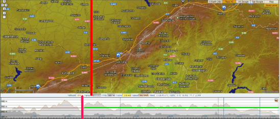
248km/261km Flights

So how do we get an easy 100km without having to deal with the airspace!  Easy really.  Just shift the launch point further to the west so that we reach 100km before we reach the airspace.
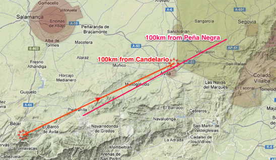
100Km from PN and Canadelario

Luckily we have just such a take off at Candelario which we used almost every day 11 years ago during the windmill crisis when we were prevented from using Peña Negra.  In fact there are two sites in that area, one at the statue of the Virgen near the ski station which we used during the 1992 Sierra Classic International hang gliding competition, and the other the “Plataforma” directly above Candelario.

Both these launch sites take winds from W to NE similar to Peña Negra and also in that the valley breeze makes them flyable most days even with geostrophic back winds.  The launches are at a similar altitude as Peña Negra (1900m), but the  mountains at Candelario continue up to 2400m, which helps a lot on south wind days as they offer good blocking.  We are also negotiating access to the top of the ski station which would give a a fantastic South take off at around 2200m.
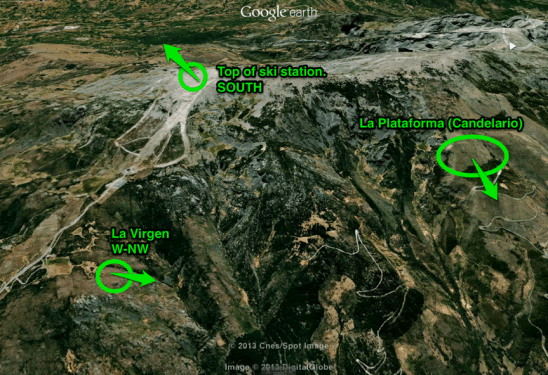
Candelario/Bejar Sites

I made 99.8km (a new Spanish record – and a shame about the 200m) from the Virgen launch during the Sierra Classic in 1992 on an Airwave Voodoo 1, which was an high performance glider for its time with a glide angle of around 6 to 1.

That same week I also made my first exploratory flights across the Gredos to the south, though with the poor performance and skills I was consistently decked in the subsidence on the other side.   Improvements in glider performance now make flights to the south much more realistic (such as Tomas Puthod’s 300km and numerous epic flights during the XC Opens events from Peña Negra).

After the 1992 event we did not go back to fly there much as of course we have a fantastic launch directly above home in Piedrahita from where in the 90’s many records were broken.   However, maybe now it is worth the effort of returning if we get an epic forecast with a base significantly over 3000m and a SW airflow just to make sure we bag an “easy”  100km to Avila before the stress of ducking under the airspace to make the 200km mark.

Can we still make 200km and be free of airspace?

Yes we can.   Once again we have to move launch site and go to La Lastra del Cano.   Lastra is perhaps one of the best XC launch sites in Spain and is the launch site of 3 European Records over the last 20 years.  We have run a few PWC tasks there, one of them being the 175km race to goal in 1995 which until recently was the longest task ever achieved in a PG competition (around 50 pilots in goal and numerous FAI National  Distance to Goal records claimed).

There are a few problem with Lastra.  The principal one is that for many years we have been prevented from flying there by La Junta de Castilla y Leon.  This seems to have been relaxed over the last two seasons and we have had some very good flights there recently.  We seem now near to negotiating legal access.  The other problem with Lastra is that as it faces south, the anabatic wind comes on very strong quickly so we need to be there early.

The Map below shows the track from Lastra to make 200km without airspace restrictions and is a common line with good landing and road communications.  It is a similar track as I made in 1993 when I made my European Record of 163km (which was almost an evening flight as I took off round 4pm on loaned oversized Firebird Navajo).

This track we would use when there is quite a bit of south wind and the wind would be over the back at Peña Negra. On the Classic days when we fly from Peña Negra to Segovia or beyond, you could similarly launch early at  Lastra, though by early afternoon the wind may switch to the north, and you would fly the convergence line going more towards Avila/Segovia.
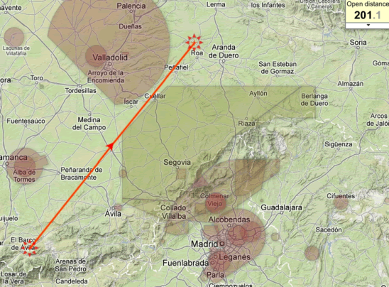
200km from Lastra

More thoughts on the Candelario/Bejar and Lastra Launches

The landing fields at Candelario are not as good as at Peña Negra. There is a nice landing quite high up that we use which is a little like landing at the Bees area in Piedrahita; near the road and allowing a quick ride back to launch for another attempt.

One possible advantage of using Candelario is that pilots who bomb our en route in the first 40kms will of course be near Piedrahita, and if the conditions allow may get a 2nd opportunity from Peña Negra.

We would mainly be using the Canelario sites when the forecast thermals are above 3000m. With predicted thermal tops below this we may just as well use the Piedrahita site.

We would never bother with Candelario for evening flying. The Piedrahita range is much better for those restitution flights and we are also landing back at home.

Conclusion

Many of our regular clients who have been coming out for many years have perhaps not made the 100km mark. Perhaps there are various reasons why a 100km is not made as often as it might be:

One of those was the problem we had in keeping track of our pilots for the retrieve. This limited ranging too far from the major roads With our live tracking system this is now less of an issue and 2012 gave us more 100km flights.

Another issue has always been in trying to maximize flying amongst the whole group. This would often mean curtailing the flight of a few to enable the whole group to re-fly in the evening. In 2013 we hope to be running 2 vans during the peak months (if client numbers permit). This should allow us more flexibility to follow pilots till sundown whilst getting most of the others back for an evening soar.

Many potentially long flights end at Avila due to the encroaching north wind or simply because of the maneuvers to fly further north into the Notam area. By simply shifting our launch 40km to the west we need neither fight the headwinds nor duck under airspace to get our 100km….and also it is a shorter retrieve at the end of the day.

Live Tracking System 2013

Perhaps the key role of the XC fly guide is to keep track of the progress of clients at all times, to offer advice and assistance when needed and to ensure that when clients land the retrieve vehicle gets to them as soon as possible. To carry this out, the guide must not bomb out, be very good at scanning the air for his clients and the radio communication system of each member of the group must work. This puts a high work load on the guide and the radio is often full of the chatter of instructions between guide and the retrieve driver, which can be distracting and irrelevant for the pilots still flying.

Keeping contact with a group of varying abilities becomes more difficult as the day develops, with often more than 20km between those pilots at the front and those trailing behind. Pilots with radio failure often decide to land if they no longer have visual contact with the rest of the group. This distancing between guide and clients tends to make us less likely to move away from the main highways or previously planned routes for fear of difficult retrieves. This is a great shame as the freedom to explore and to take advantage of unexpected lines of lift is diminished.

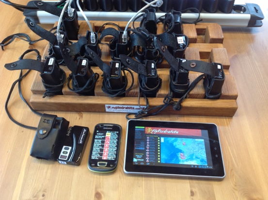
Live Tracking equipment /trackers/leather holders/ mini USB chargers/Smartphone and Tablet

There have been many equipment related improvements and introductions that have made XC group flying easier and safer. These include the wider use of GPS and mobile phones and more recently the leap in performance of CEN B class wings, which has opened up XC flying to a wider spectrum of pilots. One of the latest gadgets is the live tracker and during the 2012 season we decided to develop a system for its use in guiding XC groups to help solve many of the problems of fly-guiding. Using live tracking would have the benefit of making position calls from the air unnecessary and the retrieve vehicle would be approaching the pilot on landing rather than waiting for an SMS or phone call after the pilot lands.

Our organizing role in competitions including the 2011 Worlds in Piedrahita gave us hands on experience of using live tracking for XC racing. We had been contemplating for sometime the use of SPOT with our XC clients, but the immediacy and elegance of live-tracking with a GPS/GPRS unit and the advantage of being able to see detailed 3D tracks for post fight analysis made this system more attractive, especially since during the Worlds we saw that the GSM signal was good throughout most of our normal XC flying region.
In a competition with up to 150 pilots the retrieve is normally handled by a program such as FASTretrieve with pilots sending individual SMS messages or phoning the organization HQ from from where buses are coordinated. For managing a small group of pilots going XC along a non predetermined route we wanted a system that was easy to use from a vehicle and in the air.

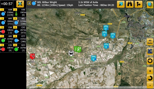
3 screen used on smartphone version

The airborne guide and vehicle driver would need to know at all times where the pilots are, so if there is loss of visual or radio contact the pilots can confidently continue their flight and may choose to take more favorable routes if presented, even if it further distances them from the others. Radio communication could then be limited to the more useful discussion of conditions and strategy.

Over the last year we have developed such a mobile system, which gives all the information needed from a glance at a tablet in the retrieve vehicle or a smartphone with the airborne guide This system is based on the the hardware and software developed by Manolis Andreadakis ofLivetrack24.com. Pilots and the retrieve bus carry GPS trackers which transmit over the GPRS network. These send the GPS location every 5 seconds or so to the Livetrack24 server. This data is then used on the Flypiedrahita website to set up the various summary pages we require.

After the location of the pilot, the most important information is the height of the pilot above the ground. This combined with the speed over the ground can be used to determine whether the pilot has landed. The height above sea level is given by the GPS, we use the radar data provided by the NASA Shuttle Radar Topography Mission for the elevation of the land. Free for us,but $200 billion for the American tax payers.

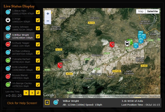
We have 2 main summary pages, one for a tablet screen and another for the smaller smartphones. Each pilot is represented by a tag which is blue for flying, green for landed and red for device off/no signal, along with information which allows the guide and driver to see the relative distance, direction and altitude of all members of the group.

Website system in 2012

2012 Van tablet system using tablet GPS
More detailed information on any pilot can be obtained with a single button press which provides a Google map view of their location, their position relative to the nearest village or town and GPS coordinates if required for the emergency services.

The tablet version displays a map of the pilot’s locations with the option to zoom to an individual or a selected group of pilots. It will also display directions to a pilot’s location. As the van begins to fill up with retrieved pilots, we keep active on the map only those still in the air or landed but not retrieved. The driver will of course focus on those markers turning green (landed). However, he no longer needs to chase every deviation of the flight path of those in the air, but can relax and see how things develop on the tablet screen and need only chase when he sees that people are getting low or if their marker has turned green.

Of course when a pilot’s tag goes green, we only know that he/she is on the ground, not if he/she has landed safely. So we do need radio confirmation of a safe landing. If there is no confirmation by radio or phone message we have an exact map reference of a possibly unconscious pilot. If there is a serious problem and the pilot is conscious and needs help, then he or she only need to press the SOS button on the device which then sends a text message containing coordinates which we can immediately give to the rescue services, even before we ourselves have reached the scene.

The main operational problem we encountered was the minute or so delay in the transfer of the location data from the trackers, via the web-servers to the display device. Not a problem for locating the pilots, but a big problem when trying to locate a minor turn-off in the retrieve van at 50 kph. This has been solved for 2013 by accessing the onboard GPS in the tablet which provides an instantaneous position.

As all these summary pages are all web applications, they are available to anyone using any smartphone, tablet or PC with an internet connection. Pilots can enter their particular tracker number to see all the distance and direction information relative to themselves. This is used most on landing to see how far the retrieve is away and how their other flying buddies are getting on.

Likewise all this information is live on a page on our website, so friends of pilots back home can follow their progress. Following the detailed live tracks of multiple pilots is most easily done using a PC with a mouse, as it requires high level of interaction from the viewer. For those at home who want to track each thermal circle, or for ourselves when doing post flight analysis, more detailed 2D and 3D views are available on the Livetrack24.comwebsite, where there is a dedicated page for our trackers.

Near Avila with onboard smartphone system

During this season thesystem has reduced my flying workload dramatically, whilst improving the XC potential and safety for our clients. We have had more big flights and personal bests by pilots flying outside the usual classic convergence route along the N110 highway. It has alsomade it more interesting for friends and partners who are able to follow pilots exploits on the website from the home or office, often making encouraging or commiserating comments on the shoutbox.

Changes for 2013

We would also like to take the opportunity to announce a few changes for next year’s flying season.

Extra Pilot Spaces for the Big XC Months
Our decision to open the booking for 2013 earlier this year has resulted in most of the weeks in June to early September being fully booked before our usual booking calendar publishing time in January. We have had a number of emails from disappointed pilots who have not had a chance to book weeks that are convenient for them.
We have therefore decided to increase the limit on the number of pilots we take during the most popular months of June to September in 2013 to 16.
The introduction of another vehicle and the further refined live-tracking system will enable us to offer an improved retrieve service. Two vehicles will allow more flexible retrieves and enable those landing early to get back sooner (perhaps for another go), rather than spending the day on the road chasing those still in the air. It should also give us easier airport runs with more scope for late and early pick-ups.
For the extra pilots we will offer a “flying only” service, without accommodation, breakfast or evening meals, at a reduced price.
We can help you arrange your local accommodation. For groups we can organize another house or we can assist individuals with hotel reservations. For those who prefer a higher standard of hotel accommodation, we now have an agreement with a 4 star hotel in El Barco at almost 50% discount for our clients. The latter is an excellent option for those coming with non-flying partners and a hire car.
Full details can be found on the booking pages on the website.

Trips to Southern Spain
We have also once again started our trips to southern Spain during October, November, March and early April as the XC and thermal soaring gets going earlier and tails off a little later down south.

Our New Admin Manager
Paul Russell, who has been our webmaster for many years and the brains behind our new “Live Tracking” system, is now taking on the role of our Admin Manager and will be dealing with bookings and payments from now on. Paul lives in the UK but spends much of the flying season with us. Puri will now be able to dedicate more time to her ¨Spanish Experience¨ venture.

We look forward to seeing many of you once again in 2013.

The best paragliding headset to date

Steve Uzi came over this year with one of Simon Murphy’s Zoot headsets which he was reviewing for Skywings. Steve is professionally involved in TV and sound stuff and thought a lot of the qualities of the headset. It has excellent robust screw in connector jacks, is well thought out, has a good mount for open faced helmets, a good quality foam sock over the mic, a top quality rugged PTT button and most importantly of all works extremely well. Also, unlike so many headsets sold to unsuspecting pilots, is nearly half the price of the competition. I ordered one right away from Simon.
Simon Murphy seems to be one of those constants in British PG and HG. If you look at some of the 1970s Skywings stored in my house you will see Simon advertising back at the dawn of the UK flying hang gliding history. It seems that it needed somebody like Simon to get fed up with all the other dross and produce something that works fantastically and is not the usual piece of rubbish that fails after a few flights. I have various boxes of different brands of headset that I purchased and have failed on me over the last 20 years. Some were good and lasted a season or two, but were very pricey (the Eggler headset from Switzerland and the Ultimate headset from the US were probably the best). One I had, the Vixen, was so rubbish I did not even use it long enough to break it as it just did not work without yelling into at the top of my voice.
My discovery of the Zoot headset arrived toward the end of the season. I had been using a Sandpiper set which I bought earlier in the year and had yet to break, but whose reliability was becoming questionable. The Zoot has been a joy in that I can use a conversational level of chat and I come across loud and clear. The volume aspect had been the biggest problem I had over the years.
Most of you who have been flying in groups with radios will have had a day ruined by somebody blocking the frequency due to a defective headset. With our live tracking it is now not so important if a radio goes down for the retrieve aspect, but frequency blocking by a duff radio setup makes the safety advantage of carrying a radio zero, as well as being a pain in the ear.
If you are looking for a new headset at the moment then this is the one to buy. I have not tried the closed face version, but that is normally less problematic than an open face set up so it is likely to be equally better than the rest of them.
I use an ICOM V 85 since it allows me to knock out 7Watts if I need it. The headset works perfectly with that radio. For those with the cheap teeny weeny Chinese radios which are now getting popular, then you may need to check the connector options

20121128-164227.jpg

Wings ad 1977

I imagine Simon Murphy is Skywings´ (Wings´s) longest advertiser.  Here he is in all his sideburned splendor  in 1977.  Of course not many people had telephones back in the 1970s so you will have to see a later Skywings for a phone number.  The Turfhouse address is still the same and you can even use the new fangled electronic mail which is  simon@turfhouse.com