Stronger winds and lower cloud

The approaching frontal systems are going to make things a bit trickier the next few days.

Perfecttly flyable from 8  am with a lightish NW at launch, but low clouds seem to be coming in from the NW which may obscure take off by mid morning.  these may burn off, but we will have to deal with somewhat stronger winds than previous days.  Best to stick to the valley for local flying today.  We will go up as an when the take off becomes visible again.

No apparent Storm risk, though maybe some build ups like yesterday if we get 30ºC.  Winds more SW so will not be as nice on the ridge.

12

1500

Fast run to Avila

Situation

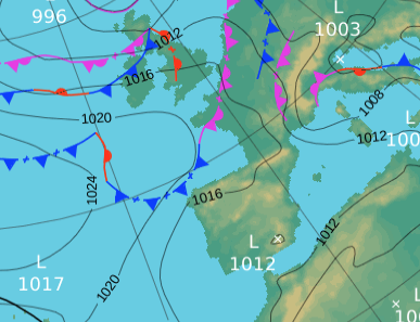
Still with our Azores high and the head low over Spain.  Pre frontal with the arrival of a chain of fronts tomorrow, although they will be stalled more to the north in Cantabria.

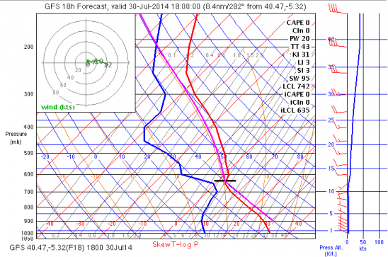
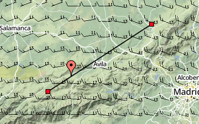
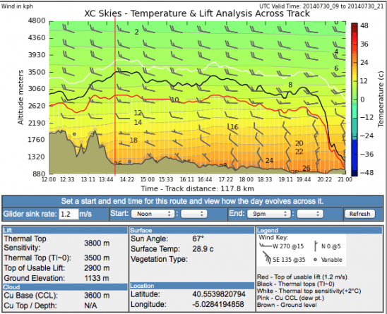
Today winds of around 15 to 20km at take off height and little more than 20km hr at 3000m.

SW, so we should get the classic convergence an a chance at Segovia and beyond.  There is more instability higher up so it is likely that there will be some congestus forming in the convergence, though storms are not forecast for this area .

1500

winds and section of track

xc section to segovia over time

What Happened.

fast glidning in the convergence with big Cus to near Avila then stopped  by the headwind and scary clouds.

NW and another Avila valley convergence day.

Not disimilar to yesterday, but warmer so probably better conditions early on.  Quite north again, so the ridge should work ok and we will get the convergence in the Avila valley from the NE coming in from Avila again.    Once again it will be tricky to get beyond Avila.  If the Piedrahita valley is working well then a circuit of this valley to the Pass then back along the middle or North of the valley towards Puente de Congosto or Barco maybe more interesting than getting kicked around the Avila valley especially if the  wind shows a lot of North.

12

1500

1200

maybe?

Light NW, inverted at 2600m early on. Avila for some

Another typical summer time forecast with the heat low building .  Light NW going a bit more W as the day goes on.  An inversion around 2600m, moving to 3000m later in the day.  A blue thermal day.  Trigger temp around 26ºC.  Top temperatures won’t be much above 27ºC so it will be a slow hard day.  Making Avila will be a good goal and hard won.

1pm

sk1200

1500


Here are yesterdays tracks of Clair and Johan who made Avila.  Anton crossed the pass, the rest of us bombed at the Quarry.

Johan green and Clair


What happened.

Strong convergence in the Avila valley just over the pass to Muñogalindo. James at Avila with 3000m+, Clair had had enough by Muñogalindo (a bit rough in the convergence).  Felipe in Niharra and Sean near Avila.  Anton and Johan on the high ground with a walk out near the Pass.

West wind, Blue thermals to c 3000m .Johan and Clair to Avila

Another good open xc day, however the wind just above the convection layer is a bit stronger which may mix down and make it a little breezy later.  Once again towards Segovia, though wind will go more north along track and as day progresses, so may be hard to go much beyond Avila.  We shall see!  Flying back certainly won’t be an option.

1500

SW, 20km/hr at take off level. Cu c 3000m

Not a bad day for XC.  There is a cold front moving through the north of the peninsula, but that should only effect the north.   Winds still a little high, but should be ok, and a reasonable day for a biggish XC towards Avila/Segovia.  Some biggish clouds, but unlikely to form storms in our area.

The week ahead looking good.

1pm

1500

NW wind and frontal

Some hope this morning as the wind is in the right direction and not too strong.  If the cloud clears the mountain we will go up for a bit of local soaring.

1500

middday

Cooler, W c20km/hr

Wind at launch is directly on the hill at 8.30 am.  forecast is for increased instability , so we shall get bigger cloud build ups, with probably congestus in the Avila valley.  Storms not predicted in this area, but further to the N and E.

my internet connection is going very slow so the maps will go up later.

Leaving for the hill (PN) at 11am.


SW, high base, stronger wind and SW convergence

This is the big open distance day of the week, however the winds are stronger so earlier in the day it may be a bit uncomfortable.

Winds at launch at 8.30am are light over the back, which is a good sign that it should come on at PN (I expected it to be much stronger at this hour).  We will watch the development at PN, and hope to fly there rather than lastra (it direction is along the slope at both). The sun should bring it on at both launches, but PN should be a little less turbulent.

Mainly blue themals but in the convergence I imagine we will see Cu c. 3800 to 4000m.

A  typical summertime pattern with the Azores hight and a heat low forming over the Peninsula.  Introduction of some cooler air at higher levels will give some storm in some parts today, but more to the pyrenees and North.  A weak trough from mid day tomorrow will give more clouds and risk of build up, but less wind tomorrow.

1500

x section

NW 3000m+. 7 out of 8 of group around Avila.

Winds lighter and more to the NW with a heat low developing.  Typical good conditions for summer in this area.   The NW may stop us at Avila, but this is certainly a day to reach Avila at least.

wind at take off at 8am is very light and on the hill.

1pm

late afternoon

winds at thermal tops and section

section