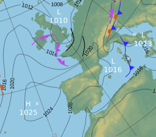
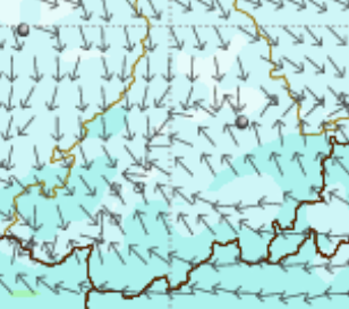
Light winds. NE drift and warmer

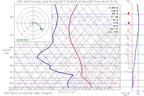
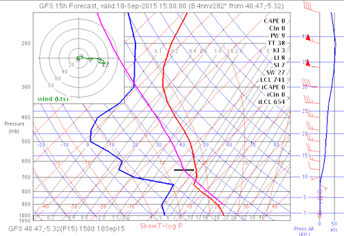
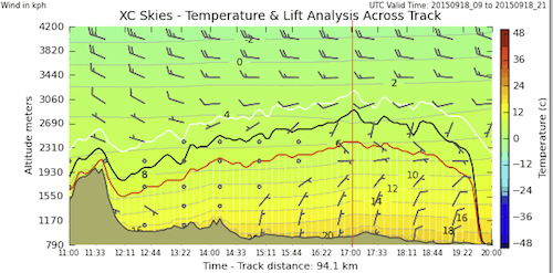
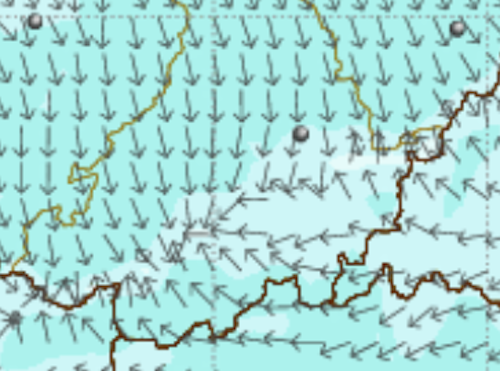
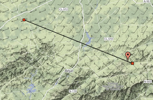
At take off at 9am the wind is gently from the SE,  however, with the forecast light winds it should come on to PN.  If not then we may go initially to Chia the SE site.  Conditions may allow a circuit flight, but if the base stays low (there is an inversion around 2600m) then I expect we will be flying towards Barco and the Tornavacas Pass.   The best route for open distance would be more to the NW, but we are likely to find contrary winds after around 25km.  All in all a nice gentle day as we enter this run of more summer like weather.

Screen Shot 2015-09-18 at 09.27.21 Screen Shot 2015-09-18 at 09.21.58 Screen Shot 2015-09-18 at 09.26.58 Screen Shot 2015-09-18 at 09.26.34 Screen Shot 2015-09-18 at 09.24.41 Screen Shot 2015-09-18 at 09.22.15 Screen Shot 2015-09-18 at 09.25.01

Luke at RAC pilot caricature

Here is Luke wearing his aviator googles and helmet which he flies his pg with.  I painted him in the RAC 1917 uniform with period plane behind.  Origional painting about 90cm tall, this is the low res 800 px version.

luke2 copy

Much better flying weather

Well, the horrible stuff has gone through and now we are getting the change for the better which looks like it will last well towards the end of next week.  The aforementioned “veranillo de San Miguel”, or Saint Michaels little summer.

Wind at take off at 9 am is not that strong and cross on.  We need to wait until there is a bit more cloud dispersal but we will get going as soon as feasible.  Conditions for an XC towards Avila maybe ok with climbs later in the day to near 3100m.  The will be cumulus forming and the wind in the Avila valley is looking stronger that ours.

Screen Shot 2015-09-17 at 09.01.23 Screen Shot 2015-09-17 at 09.00.23

Screen Shot 2015-09-17 at 09.01.32 Screen Shot 2015-09-17 at 09.00.09 Screen Shot 2015-09-17 at 08.59.57 Screen Shot 2015-09-17 at 08.59.45 Screen Shot 2015-09-17 at 09.02.58

A tiny chance at the end of the day.

Obviously there is no chance for decent flying today.  However, there is the remote chance (forecast on the local) of a drop in the wind after the front passes later in the day.  The wind should be on PN at that time so we will keep an eye on the windsock at take off (though it has probably been blown away).  Tomorrow still looking OK and the rest of the week light wind and fine.


Awaiting the little summer of Saint Michael.

The next two days will be unflyable, however, from Thursday we have a recovery and then for the following week the meteorological occurrence which is termed the Veranillo de San Miguel.  This is so common it has a name and refers the normally week long period of good weather with higher temperatures as we would get in high summer.  This is usually the last blip of summertime before we decline into the cooler temperatures of Autumn.

So, the next two days are rubbish, but from then on it is looking good… so Derrick and those out next week things should be good.

West winds, base rising to 2500m

Today is something of a transition before the very deep low comes in and makes things very unflyable for tomorrow and wednesday.  After that the Azores high will stabilise things and Thursday to Saturday should be very good flying days.

Today we will try to make the most of things. The base will not go very high and we will have low stratocumulus clouds most of the morning.  As soon as they clear the take off we should try to get a flight in.   The conditions in the valley should be quite buoyant, but we will go straight back up as the conditions should clear well by early afternoon giving decent thermal soaring conditions.  The wind will come up a little, and that, along with the low base will stop us going XC further than the end of the valley.  Evening soaring should be good.

Screen Shot 2015-09-14 at 08.48.58Screen Shot 2015-09-14 at 08.48.58 Screen Shot 2015-09-14 at 08.48.47Screen Shot 2015-09-14 at 08.49.44Screen Shot 2015-09-14 at 08.50.03

Screen Shot 2015-09-14 at 08.50.55 Screen Shot 2015-09-14 at 08.50.39

today 1pm

today 1pm

Tuesday

Tuesday

Wednesday

Wednesday

Thursday

Thursday

Lizzie the Mountain Runner. XC magazine

Here is my Illustration for XCMag 164. This one is of Lizzie the Mountain runner, who one of those amazing women who manages to multitask kids, work, hobbies and husband. Charlotte King was the reference I was given. However, when I did this last winter I was still new to the art of caricature and went for a more generic cartoony type. I used Norman Rockwell´s illustration of Liberty as an inspiration and pose. I also wanted it to have the appeal of a children’s book illustration. Here it is below along with the original Rockwell illustration.

Screen Shot 2015-09-12 at 17.59.51

Screen Shot 2015-09-12 at 17.55.23

The mountain runner copy

Unlikely today.

The cold front is pushing in and we are in a low pressure sector and the winds are high from the SW. Best chance is early on at La Lastra but enjoyable flying is very unlikely.  I´ll be around at 10am to see what we might do on this potentially fun packed day…Walking routes, city visits, ham tasting, kite buggies, bare knuckle boxing etc…

Screen Shot 2015-09-12 at 09.06.32 Screen Shot 2015-09-12 at 09.09.22 Screen Shot 2015-09-12 at 09.09.42 Screen Shot 2015-09-12 at 09.06.43 Screen Shot 2015-09-12 at 09.06.08

PB for Gunnar 175.4km.

Gunnar 175 out by PG.  Back by Van.

Gunnar 175 out by PG. Back by Van.

Screen Shot 2015-09-12 at 15.46.37 Screen Shot 2015-09-12 at 15.46.19

A big day from Lastra today with Gunnar making his PB of 175km.  Curiously, his last PB was in 1995 in the PWC race task I set to Acrones from La Lastra.  That 170km goal was something of a revelation in the PG world when around 50 pilots made it.  Even now nearly 20 years later I am unsure if that has been matched  in a PWC task. Great flights for many other too, with Simon the next down with around 150km.  Even I went along for the ride.  The last 60km or so were done without thermalling running the convergence at around 60km /hr at trim.  No Cu clouds , must mainly a blue day and some high level Altocu/ mashed potato along the convergence at the end.  Photos by Gunnar, the yellow Iota is me (Steve)


Classic SW convergence day for open distance.

From the Hirlam surface winds we can see a typical convergence setting up running for about 200km in the afternoon.  Winds are SW and on the stronger side.  It is unlikely to be any good for decent evening soaring so this is the day for sure to go big if you can.  Thermal tops altitude increases throughout the day but is low to start with so it will be easy to go down early in the day, however if you are in the air still around 3pm you are sure to do something big.  The predicted convergence does not take us quite through the airspace corridor to the north near Valladolid so be careful with the  Madrid TMA limits.  The best route for the convergence is well to the North so we won’t be crossing the Pass today but going to the flatlands to the North.

For those interested in learning about Skew T diagrams then the best site I know for tutorials is .  https://www.meted.ucar.edu/.

Nigel P.  If you get to read this, can you bring across my Kobo.

Obviously we will be going to La Lastra.  Briefing around 10.15 and leaving 10.30.

Screen Shot 2015-09-11 at 08.45.44 Screen Shot 2015-09-11 at 08.45.29 Screen Shot 2015-09-11 at 08.45.12Screen Shot 2015-09-11 at 08.53.05 Screen Shot 2015-09-11 at 08.52.58 Screen Shot 2015-09-11 at 08.49.01 Screen Shot 2015-09-11 at 08.46.28