Live Tracking System 2013
Perhaps the key role of the XC fly guide is to keep track of the progress of clients at all times, to offer advice and assistance when needed and to ensure that when clients land the retrieve vehicle gets to them as soon as possible. To carry this out, the guide must not bomb out, be very good at scanning the air for his clients and the radio communication system of each member of the group must work. This puts a high work load on the guide and the radio is often full of the chatter of instructions between guide and the retrieve driver, which can be distracting and irrelevant for the pilots still flying.
Keeping contact with a group of varying abilities becomes more difficult as the day develops, with often more than 20km between those pilots at the front and those trailing behind. Pilots with radio failure often decide to land if they no longer have visual contact with the rest of the group. This distancing between guide and clients tends to make us less likely to move away from the main highways or previously planned routes for fear of difficult retrieves. This is a great shame as the freedom to explore and to take advantage of unexpected lines of lift is diminished.
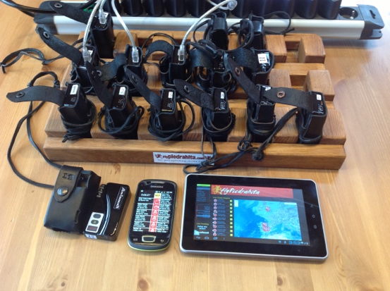
 Live Tracking equipment /trackers/leather holders/ mini USB chargers/Smartphone and Tablet
There have been many equipment related improvements and introductions that have made XC group flying easier and safer. These include the wider use of GPS and mobile phones and more recently the leap in performance of CEN B class wings, which has opened up XC flying to a wider spectrum of pilots. One of the latest gadgets is the live tracker and during the 2012 season we decided to develop a system for its use in guiding XC groups to help solve many of the problems of fly-guiding. Using live tracking would have the benefit of making position calls from the air unnecessary and the retrieve vehicle would be approaching the pilot on landing rather than waiting for an SMS or phone call after the pilot lands.
Our organizing role in competitions including the 2011 Worlds in Piedrahita gave us hands on experience of using live tracking for XC racing. We had been contemplating for sometime the use of SPOT with our XC clients, but the immediacy and elegance of live-tracking with a GPS/GPRS unit and the advantage of being able to see detailed 3D tracks for post fight analysis made this system more attractive, especially since during the Worlds we saw that the GSM signal was good throughout most of our normal XC flying region.
In a competition with up to 150 pilots the retrieve is normally handled by a program such as FASTretrieve with pilots sending individual SMS messages or phoning the organization HQ from from where buses are coordinated. For managing a small group of pilots going XC along a non predetermined route we wanted a system that was easy to use from a vehicle and in the air.
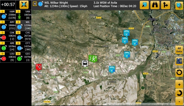
 3 screen used on smartphone version
The airborne guide and vehicle driver would need to know at all times where the pilots are, so if there is loss of visual or radio contact the pilots can confidently continue their flight and may choose to take more favorable routes if presented, even if it further distances them from the others. Radio communication could then be limited to the more useful discussion of conditions and strategy.
Over the last year we have developed such a mobile system, which gives all the information needed from a glance at a tablet in the retrieve vehicle or a smartphone with the airborne guide This system is based on the the hardware and software developed by Manolis Andreadakis ofLivetrack24.com. Pilots and the retrieve bus carry GPS trackers which transmit over the GPRS network. These send the GPS location every 5 seconds or so to the Livetrack24 server. This data is then used on the Flypiedrahita website to set up the various summary pages we require.
After the location of the pilot, the most important information is the height of the pilot above the ground. This combined with the speed over the ground can be used to determine whether the pilot has landed. The height above sea level is given by the GPS, we use the radar data provided by the NASA Shuttle Radar Topography Mission for the elevation of the land. Free for us,but $200 billion for the American tax payers.
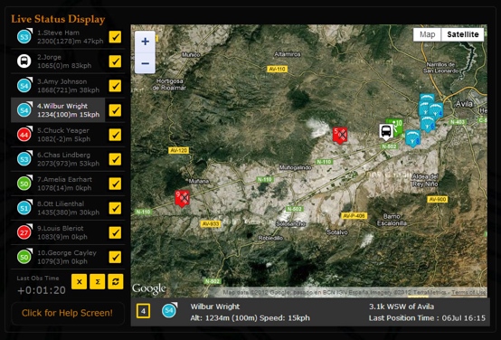
We have 2 main summary pages, one for a tablet screen and another for the smaller smartphones. Each pilot is represented by a tag which is blue for flying, green for landed and red for device off/no signal, along with information which allows the guide and driver to see the relative distance, direction and altitude of all members of the group.
 Website system in 2012
 2012 Van tablet system using tablet GPS
More detailed information on any pilot can be obtained with a single button press which provides a Google map view of their location, their position relative to the nearest village or town and GPS coordinates if required for the emergency services.
The tablet version displays a map of the pilot’s locations with the option to zoom to an individual or a selected group of pilots. It will also display directions to a pilot’s location. As the van begins to fill up with retrieved pilots, we keep active on the map only those still in the air or landed but not retrieved. The driver will of course focus on those markers turning green (landed). However, he no longer needs to chase every deviation of the flight path of those in the air, but can relax and see how things develop on the tablet screen and need only chase when he sees that people are getting low or if their marker has turned green.
Of course when a pilot’s tag goes green, we only know that he/she is on the ground, not if he/she has landed safely. So we do need radio confirmation of a safe landing. If there is no confirmation by radio or phone message we have an exact map reference of a possibly unconscious pilot. If there is a serious problem and the pilot is conscious and needs help, then he or she only need to press the SOS button on the device which then sends a text message containing coordinates which we can immediately give to the rescue services, even before we ourselves have reached the scene.
The main operational problem we encountered was the minute or so delay in the transfer of the location data from the trackers, via the web-servers to the display device. Not a problem for locating the pilots, but a big problem when trying to locate a minor turn-off in the retrieve van at 50 kph. This has been solved for 2013 by accessing the onboard GPS in the tablet which provides an instantaneous position.
As all these summary pages are all web applications, they are available to anyone using any smartphone, tablet or PC with an internet connection. Pilots can enter their particular tracker number to see all the distance and direction information relative to themselves. This is used most on landing to see how far the retrieve is away and how their other flying buddies are getting on.
Likewise all this information is live on a page on our website, so friends of pilots back home can follow their progress. Following the detailed live tracks of multiple pilots is most easily done using a PC with a mouse, as it requires high level of interaction from the viewer. For those at home who want to track each thermal circle, or for ourselves when doing post flight analysis, more detailed 2D and 3D views are available on the Livetrack24.comwebsite, where there is a dedicated page for our trackers.
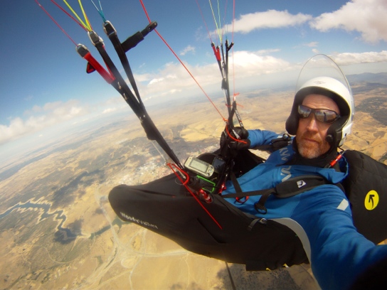
 Near Avila with onboard smartphone system
During this season thesystem has reduced my flying workload dramatically, whilst improving the XC potential and safety for our clients. We have had more big flights and personal bests by pilots flying outside the usual classic convergence route along the N110 highway. It has alsomade it more interesting for friends and partners who are able to follow pilots exploits on the website from the home or office, often making encouraging or commiserating comments on the shoutbox.
 Live Tracking equipment /trackers/leather holders/ mini USB chargers/Smartphone and Tablet
 3 screen used on smartphone version
 Website system in 2012
 2012 Van tablet system using tablet GPS
 Near Avila with onboard smartphone system
January 19th, 2013 at 18:23
Hi Steve,
The trackers were great when I was there last year, but I’m not sure how well they worked for, Chas Lindberg and Amelia Earhart?
See you in July
Fred